
- Institute of Time and Space Information Technology,GIIT
- Guangxi Institute of Industrial Technology on Stony Desertification Control
- Institute of Plus One Digital Virtual Technology, GIlT
- Guangxi Institute of Science and Technology Development
- Institute of YC Simlan New Energy Power Technology,GIlT
- Institute of ASEAN Language Intelligence, GIIT
I. Institution Profile
Established on June 18, 2021, Institute of Spatiotemporal Information Technology (ISIT) is a state-mixed ownership research institution jointly founded by GIIT as the primary investor, Professor Sun Xiyan’s innovation team (a leading expert in Beidou navigation technology at Guilin University of Electronic Technology), and Guangxi Zhuangtu Software Co., Ltd.
Rooted in Guangxi and extending its influence to ASEAN, ISIT integrates "government-industry-university-research" collaboration and merges industrial technology with scientific innovation. Its core technical focus centers on "3S+IoT": Beidou Navigation Satellite System (BDS), Remote Sensing (RS), Geographic Information System (GIS), and IoT-based Spatial Internet of Things. The institute explores three key application domains: AI-powered Beidou large-scale applications, intelligent remote sensing, and low-altitude economy.
ISIT adheres to market demand-driven R&D, transforms scientific achievements into market-ready products, and incubates enterprises across industrial chains. Committed to becoming the core engine for innovation-driven development in Guangxi’s spatio-temporal information sector and a model platform for institutional innovation, ISIT aims to establish itself as a new highland for entrepreneurship, talent cultivation, and open cooperation.
 II. Organizational Structure
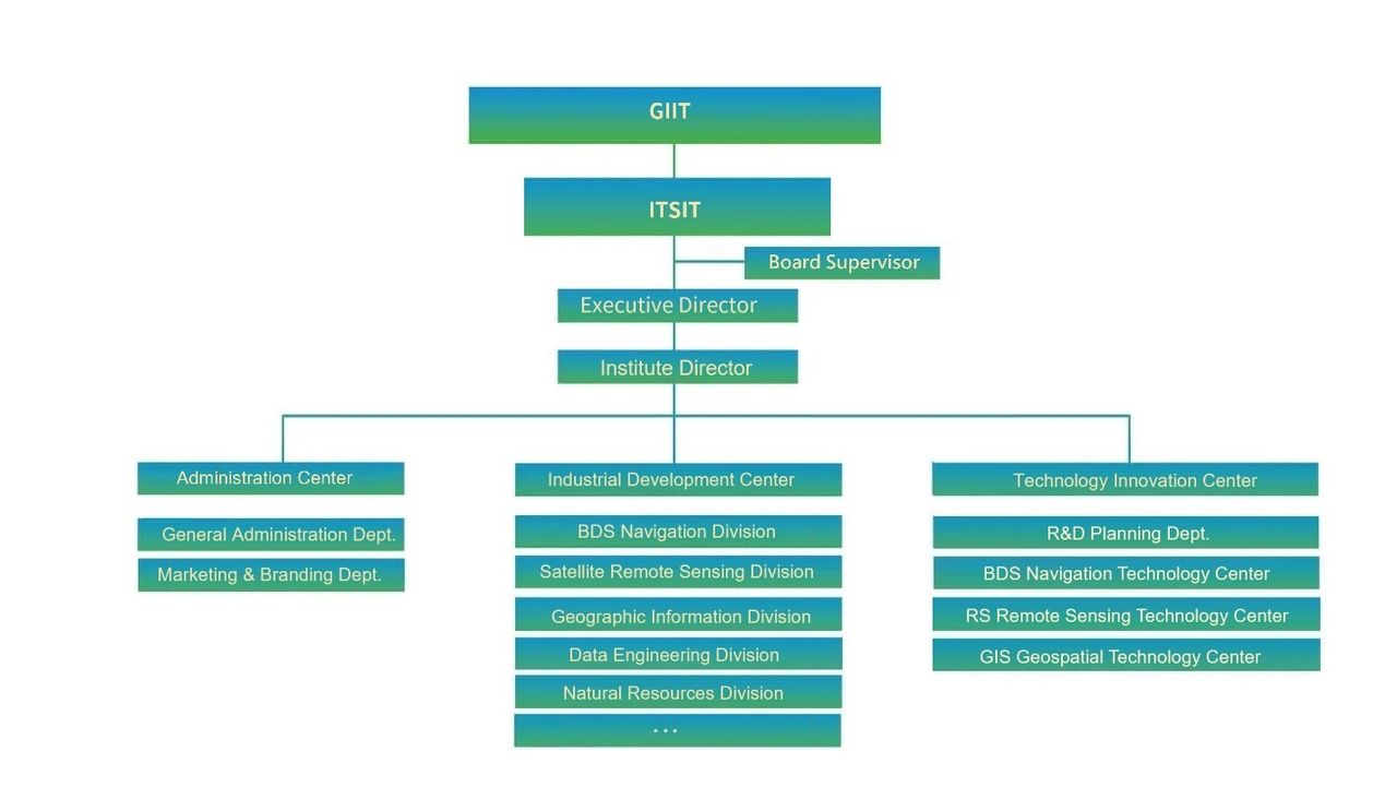
III. Strategic Plan
Goal: To establish an internationally advanced, domestically leading platform for technological innovation, talent development, and industrial incubation.
Vision: To build a full spatio-temporal information industry ecosystem based on "3S+IoT".
Strategy: Market demand orientation, independent innovation drive, and integrated government-industry-university-research development.
IV. Leading Figure
Sun Xiyan
Ph.D./Doctoral Supervisor/Researcher;
Chief Scientist, ISIT, GIIT;
Director, National-Local Joint Engineering Research Center for Satellite Navigation Positioning and Location-Based Services;
Selected for the "National Hundred, Thousand, and Ten Thousand Talents" Project;
National "Outstanding Young and Middle-Aged Expert with Significant Contributions";
Recipient of the State Council Special Government Allowance
Guangxi Bagui Scholar.
V. Core Business
3S Products: R&D, production, and sales of 3S software/hardware.
Data Production: Map data collection, processing, and model analysis.
Technical Services: Technology development, consulting, and talent training.
Engineering Implementation: Surveying and mapping, spatial planning, and system integration.
Industrial Incubation: Enterprise cultivation, park co-construction, and industry incubation.
VI. Core Technologies
BDS Navigation Technology Center:
Develops spatial monitoring equipment (deformation, displacement, attitude) based on BDS, integrating sensors (temperature, humidity, hydrology) for high-precision IoT positioning.RS Satellite Remote Sensing Center:
Conducts spatial computing, feature recognition, algorithm analysis, and model development using multi-source satellite/ UAV imagery.GIS Geographic Information Center:
Develops industry-specific systems (digital twin cities, natural resources, emergency response) leveraging spatio-temporal big data.
VII. Collaboration Models
OEM Product R&D:
Integrates 3S+IoT with cloud computing, blockchain, and 5G to create new industrial models.Ecosystem Partnerships:
Collaborates with research institutions, universities, and enterprises to build a shared development platform.Joint Engineering Centers/Labs:
Co-establishes labs (e.g., with Guilin University’s National Engineering Research Center) and recruits top-tier research teams.Industrial Park Co-Construction:
Creates spatio-temporal information industrial parks under the "government-industry-university-research" strategy.
VIII. Office Environment
Main Office Complex
Product Exhibition Area
Testing Laboratories: